Thursday, November 28, 2019

Padang Tembak Dou Mu Gong Jiu Wang Da Di Temple up to Rest Station 39 and down to the Youth Park via Rest Station 5

I have had my eye on this way up the mountain for some time. Bobbi and I found our way up to Rest Station 5 from Moongate and Youth Park some time ago. We saw that the trail continued from there out the back of the rest station, and we were told when we asked that that way went to the jeep road back to Botanical Gardens in Penang.

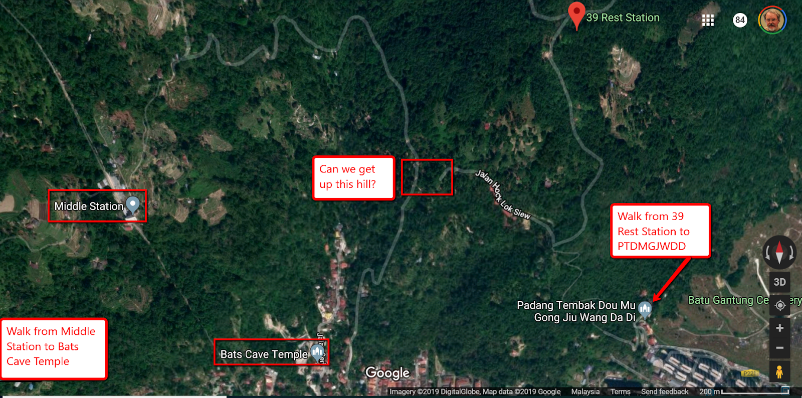
I started looking closely at maps and came to the conclusion that this way must take us to Rest Station 39 which is marked on Google Maps. I had further seen from satellite views that there appeared to be a trail from the Air Itam side up the mountain to Rest Station 39. I had in fact worked out that this trail started from Padang Tembak Dou Mu Gong Jiu Wang Da Di Temple, at the end of Jalan Padang Tembak, off Boundary Road just south of Batu Gantung Cemetary, a big green patch on the map of Penang just south of the Turf Club and equestrian center, and I found out today that I had in fact been right about this. And I had figured that if that was true then it should be possible to get a Grab to the temple (or a bus from Komtar; the temple is on the 201 and 204 bus line down Boundary Road) and walk up to Rest Station 39, then traverse to Rest Station 5 and go back down to the Youth Park or Botanical Gardens Moongate in just a few hours.

But finding the way UP from the temple (what this blog post is intended to help you do) was the main problem. It seemed more reasonable to try and find Rest Station 39 itself in walks on the mountain and then find the way DOWN from there. Then I'd know where the trailhead was in town.


In walks since then I'd been trying to find my way to Rest Station 39. So far I've missed my mark, but when out on a jaunt with the Thursday Ramblers today I did at last find my way to my goal, and I hope this post will thus explain why I left the group to set out on my own in search of this (well known to them but to me) elusive Rest Station 39, and its even more elusive trail down, which I have now found, just today.

From Youth Park yet another way to Rest Station 5

So let's start with the Ramblers and their trail uphill from the Youth Park. I was following the leader through the Youth Park and thinking I might have trouble finding that way again, but at the point we were leaving the park we passed this "Laman Flora" marker, which is where we left what looked like "park" and started up the surfaced mountain path.


We continued up this path for 5 or ten minutes and then turned abruptly up a dirt path going uphill to our right. I didn't take a picture here, but the path had tree roots forming steps which helped us navigate it smoothly (maybe tricky when wet though). That way was marked with red paint, sprayed strategically on some of the trees en route. We climbed up-slope but didn't encounter problems till we reached this place where the rocks were a little slippery. Someone had helpfully installed a rope that helped us get over the rocks.


There the trail had turned sharply uphill to the left, and we continued that way, tediously uphill, but more comfortably I thought than any of the other ways I'd tried in the past, until we came out at the top of the jungle trail onto this fairly level trail perpendicular to the one we had just been on.


Dave Peel, our leader said that the way the camera is pointed would take us downhill to Rest Station 5, and from there, there are a couple of obvious ways down the steps to Moongate or if you take a set of steps off to the right, as I recall, down a more gradual descent to Youth Park. Now, note the tree with the red arrow at the right of the picture above. That's the same arrow in the picture below which points back down the trail we just came up.

So from the view of the trail below the arrow, if I look left I'm looking down the trail to the Youth Park and Botanical Gardens. That's the way the Ramblers took. But Dave had told me, when I asked, that the trail to the right led to Rest Station 39. Oddly the place he described that I would arrive at was recognizable to me. It sounded like the newly built structure right on the Jeep Road. He said from there I could go to Middle Station, and this must have been the trail marked Moniot Road. I've been that way before and I recognized the various options, but I was surprised that that new structure would be Rest Station 39. I allowed that there should be a way down from Rest Station  39 to Ayer Itam. Dave said there was, "if you know what you're looking for."


I decided as long as I'd come this far, I couldn't resist completing my missing puzzle piece, so I headed slightly up the trail in the opposite direction, and soon came onto this bridge, with its new guardrails blocking falls into the chasm on either side.


Not long after that, I came to this juncture, with a high road and a low road.


An energetic young couple happened a long at just that moment and I asked them if they knew the trail. By chance they knew that the high road led to the Jeep Road, the place that I thought Dave had been pointing me to, because he had described a track that went back to the Botanical Garden from there, a track I'd like to take if I'm ever back there again, because it parallels the Jeep Road. This young couple didn't know where the low road went. When I looked more closely, it seemed to go where I actually wanted to go.


So I took it and sure enough, came out within a few minutes on this


It seemed to be a pleasant place, with inviting facilities


Lovely views looking out to Butterworth


And only two people there. One was a young woman holding a yoga position on a pedestal overlooking the valley, and the other apparently a caretaker, taking care of something


So I asked the caretaker if there was a way down to the big mosque in the middle of this picture


And he pointed the direction I should go, which was thankfully, and obviously, all downhill from there. The only problem with that is that the opposite direction is all uphill.


From Padang Tembak Dou Mu Gong Jiu Wang Da Di Temple up to Rest Station 39

But suppose you were down in the valley and wanted to get all that uphill out of the way in one go and then coast all the way from there to the Youth Park (where on a hot day you can have a swim in one of the several free pools there).

To start with, you'd go here on Google Maps, and look for this sign

If you came by bus you'd get off at the bus stop below the Intuk Negeri Kita apartment complex.

You're on Boundary Road, and the sign you are looking for is to the left of the entrance to this street.

Walk to the end of this road until you have to turn right.

You'll find a school on your left,

and the Padang Tembak Dou Mu Gong Jiu Wang Da Di Temple is on your right.

See the roof of the yellow building behind the first two? Take the road to your right to pass it.

Turn to the left to pass the fence on your right, and take the only way possible to the left

On your way up the road, you come to two small alters

At the second one, start up the road to the right

On on up the road. The first house is number 4. You're going to 39.

There's an open gate here


Don't enter unless you just want to look around. Take the road uphill to the right.


Post number 7 is just up the hill


Here's 18, almost halfway


Just past the sign for the Hokkein Cemetery, you come to the end of the road.


There are colorful flags here


and a small shrine. The dogs here will be wary of you, but they didn't threaten me.


Beyond this rock there is a trail marker:


Now the steps begin ...


Welcome to Rest Stop 39, but don't get excited yet.


Twenty six, only 13 to go!


Twenty-seven!


These are some heavy duty steps. They look almost rain-proof.


At the top of these stairs you come out on a relatively flat surface.


This gentleman has just come up the steps. He pointed back over his head to indicate the way for me, the way he had come, but he seemed too tired to spend much energy on conversation.


This is why I had asked him. If you're coming downhill make sure you take the stairs to the left. I don't know where you'd end up if you missed it and carried on straight.


The concrete path breaks up but is replaced by stairs.


The above photo is taken looking downhill. Just beyond here the more reliable steps verge to the right. Take your pick of pathways.


One more long stairway, but at 37, you're almost there.


At the top, follow the stairs to the right.


You've arrived!


And that's the last of the  pics I need to upload to this blog post :-)

Time and distance

On the maps, the distance of that walk is only about 3 miles or 5 km, but the gain in alitude is 400 meters, and the trails aren't US national park standard (before Trump). It took me from 9 am to around noon to do the whole thing.

Where can we go from here?


Tuesday, November 5, 2019

Sungai Ara to the Carpet

My favorite walking buddy Bobbi and me, myself, and I have been wanting to walk in the Relau hills area west of the pleasant township of Sungai Ara for some time. It's been raining a lot in Penang this past month and we were holding off for a day where it dawned clear and where the weather report gave little chance of rain till mid-afternoon.

One such day was last Sunday, when some friends were hiking to the Carpet from Balik Pulau, but we would have had to be there at dawn, 6:30 a.m., and at 4:30 that morning it was pouring down rain, and our friends Whatsapped that the walk was off. If you're walking on jungle trails they can get very difficult when wet, and even concrete paths can be slippery after a rain. But by dawn the day was clear and the people in Balik Pulau went anyway, too late by then for us to get our tails over there, since we live about an hour away from Balik Pulau, and they had a nice outing as we could see from their pics on Whatsapp.

They had also Whatsapped maps and route details from which we could see roughly how to reach the Carpet from our side. So a few days later we woke up to a day that fit the requirements, and Bobbi and I got a Grab (the local e-hailing service) to the spot marked Fig Tree Hill Resort on the map below, on the outskirts of Sungai Ara, and started out the rough concrete road heading due west, looking for the spot where we'd have to turn north and gain about 200 meters elevation to reach the Carpet.

You can see on the satellite map the KFC in Balik Pulau where our friends had wanted to meet us the Sunday before. They most likely drove a part of the way before jumping off for the track to the Carpet.

I had been tracking information on this walk in a Google Doc shared publicly. This link will take you to the Sungai Ara portion of that doc where you can see some of the information we had accumulated:
https://docs.google.com/document/d/1xKvAUrAPWVtrBY7ioiVflW1chqCbKu3Kkx6MBMhJD3A/edit#heading=h.65se2zeu0tl3

The jumping off point is just uphill from the public park with the big Sungai Ara lettering in it. The road circulates around the park where at the northwest corner you'll find a fine Buddhist temple which gleams in the sunlight. Just uphill from there along Lorong Kenari 8 you find a Hindu temple which I had read was under construction, and it still is. Turn right there and the walk starts at the poor road on the right just past the Hindu temple. That road takes you due west along the Sungai Ara (sungai means river in the local language).

This is the uphill side of the Buddhist temple, gleaming on the western side on our way back to Sungai Ara park as we ended our trek at the end of the day

The Hindu temple, taken by poking a camera through the locked gate

The turning for Fig Tree Hill Resort is to the right, just past the lamp post

This is the view looking back down the road back toward the Hindu temple

We knew that the walk we were planning followed a bike route, so it should have some kind of pavement the whole way to the Carpet. Indeed the walk west from Sungai Ara was straightforward. It's an easy, level, saunter along that road with the river gurgling on your right, and even a wooden bridge over it where locals like to park and have picnics, as there is a temple up a side road off to the right there. You just follow the faded signs for the real Fig Tree Hill Resort (I think the point marked on the Google map in Sungai Ara was place there by the resort so its clients can find the turning; the real resort appears to be further along that road.)


After a half hour you'll come to what everyone calls the "shed" but it's really more like an open air pavilion. There are a number of concrete tables and benches under the roof so you can't miss it, and there's a sign on it that points north and says "The Carpet".

The sign on the tree points to Fig Tree Hill Resort not far up the road

The red-and -white-on-black sign on the nearest upright points the way to The Carpet

So far so good. But unfortunately that was the last sign we would see pointing the way to the Carpet, and we had come on a week day so there was no one else around we could follow. We assumed we follow the concrete road which led us uphill about a half hour later to a green gate behind which there was a house under construction.

There were no road markings but there were more concrete roads heading to the north steeply up the hill from there. We followed the most obvious but eventually came to a metal gate blocking the road with signs on it stating clearly that its purpose was to keep people and bicycles out (i.e. a bike icon with a red X over it). So we went back down the hill and tried the two other ways. One went steeply uphill almost to the top but ended in someone's durian plantation. We pursued footpaths through the plantation until these too fizzled, but it was obvious no one would be biking downhill from here. So we went back down and tried an even steeper concrete road heading up, but this one joined with the road we had just been on, leading back up to the plantation.

We figured we must have missed another turning somewhere and indeed we had. But though we poked around concrete roads heading uphill, these either fizzled or appeared to be taking us back to where we had been before. Eventually we worked our way back downhill and got as far as the shed where we sat down exhausted on one of the benches. We had just spent an hour and a half in needless excursion.

The problem was there were many turnings and no signs on the possible routes heading uphill from the shed. This blog post https://www.penangcycling.com/2016/02/08/reverse-carpet-cycling-trail-at-sungai-ara-penang/ shows a "Carpet" sign (picture link: https://i0.wp.com/www.penangcycling.com/wp-content/uploads/2016/02/wp-1454953544888-1.jpg?zoom=1.5&w=640) but this sign is (1) way up the trail from the shed, in the area of the clearly signposted hairpin turns 1-12, and (2) looks removable. It wasn't there when we passed that way. But it wouldn't have helped us find the first turn on the right (as it turned out) past the shed. Our problem was inability to find the way up to those obviously signposted hairpin turns when faced with so many unmarked junctions. We had chosen the more obvious "main" roads, but there turned out to be a secret way up.

While resting and drinking water we discussed what to do. We thought maybe to continue on to Fig Tree Hill Resort and maybe take refreshment and talk to the people there about where to go. We were just reconnoitering and we were out for some exercise and we figured we'd get there eventually but maybe not today. But just then a bicyclist appeared, the only other cyclist we had seen that day, and made the turn to the carpet. We hailed him over and he stopped for us.

He was very friendly. His name was Lee, and to make a long story short, he showed us the way.


Bicyclist Lee makes this run up to the Carpet and back every day, he says :-)

Just 100 meters or so up the hill from the shed, you make the first right turn. You take the high road and not the one marked private property.

Here is what the first turn looks like

The structure just up the road in the picture above looks like this. 
If you pass it you're on the right path, for now.


At this point in the trail I was able to keep up with Lee and see where he was going

Not far from there you come to your next junction. Don't be fooled by the bike tracks in the road ahead, or by the pile of tire tubes in the bushes to the right. If you go that way you'll find it soon dead-ends in the jungle.

Bobbi is pointing the right way in the picture below


We had actually found our way this far on our own just "poking about" before we ended up back at the shed and luckily encountered Lee. But the way from here requires a guide. Lee realized this because though he rode on ahead, he waited for us at the next critical right turn.

Here it is, ten minutes up the trail from the previous junction. Incidentally, there are a lot of dogs in this area. You can neutralize them by carrying a stick.


When you get to this turn you take the LOW road, the one marked Private Property.


Then you come to a gate and pass around the gate on the right to continue uphill.


Maybe 50 meters beyond the gate you find a path going up to the left. Dead ahead you see a reddish shack. Go left up the path.


Now you find yourself in the most pleasant part of the mountain. You're on small pistes and the lefthand path leads you into this pleasant area, pictured from above:


Lee continued up the trail. He told us we couldn't get lost and he'd meet us at the top


Now we were on the trail with the signposted hairpin turns. Here is one of the most radical.


Nice views of the thick forest from here


And of Jerejak Island and Perai when you reach the top


So here is the Carpet, a much smaller space than we had expected. There were half a dozen dogs here who greeted us loudly and aggressively. We showed them our sticks and after a minute or so they calmed down and went to rest in the shade. We did the same. We were surprised that the clock on one of the sheds gave the correct time, a quarter to the hour when we arrived, 3 pm when we left. When we left the dogs let us pass without further incident.


Metal chairs and swings are strewn here. Below, we are relaxing in the shade:


We were exhausted when we finally arrived here. It took us an hour and a half to get back down to the Hindu temple and it should have taken about 2 hours coming up. But we had trekked up and down for an extra hour and a half on needlessly taxing Sisyphus trips. Next time we come it will be a breeze because we'll know the way.

And if you're reading this, you'll know the way too :-) Good Luck!

Bukit Olivia via Lily Pond, Mt. Erskine, and Waterfall Road trails

Bobbi and I have been monitoring the covid epidemic closely in Penang. The government imposed emergency movement control orders in March tha...